
The Lateen Sail Part 2
This is the second part of an essay by regular contributor Duncan Blair on the Lateen Sail. Part One can be found HERE
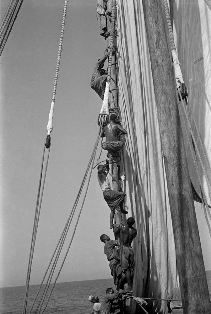
Sailors climbing and working aloft on the great lateen yard. Alan Villiers. Collection: National Maritime Museum, Greenwich, London
The Indian Ocean, The Arabian Sea and Beyond- By Duncan Blair
In this post, Part Two of The Lateen Sail, I return to the role and importance of the lateen sail by looking at monsoon season winds, trade routes and trade goods.
RE-CAP.
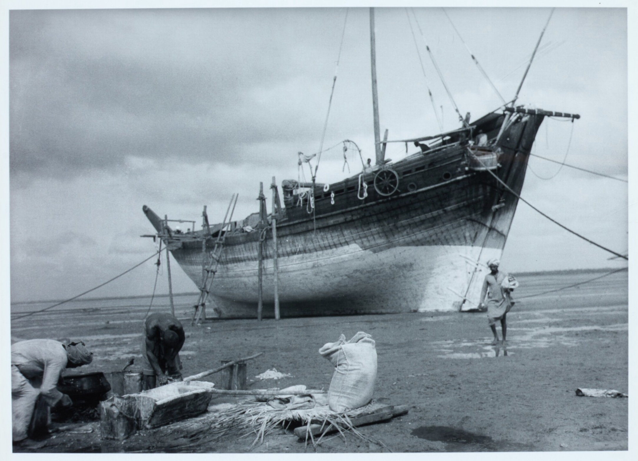
[ The “Boom”, dhow type that Alan Villiers sailed on, was 105 feet long and capable of carrying 200 tons of cargo.
She was built with teak planks, brought from the Malabar coast of India. Like all other dhows, her lateen sails were equally powerful when sailing “large” or going to weather.
Her large crew—typical of dhows—provided necessary muscle power to trim the sails, tack and gybe and to control the very long lateen yards when running before the monsoon wind.]
In thinking about dhows, their trade routes and cargoes, it sometimes begins to feel like the Indian Ocean, Arabian Sea and the Bay of Bengal were a parallel universe, in many ways a mirror image of the Mediterranean, Atlantic, North Sea and the Baltic Sea; different sailing rigs, cargoes, winds and geography, but still having some striking similarities.
THE MONSOON SEASON WINDS
Alan Villiers was a well-educated man, with a lot of practical experience with many types of sailing vessels in many different oceans.
He was also “old school”, an experienced author and strongly opinionated. He states, unequivocally, that “The word ‘monsoon’ means ‘season’. It has nothing to do with the typhoon or any other kind of storm.”
He goes on to say “On the western side of the Indian Ocean, down as far as the Mozambique Channel… and on the Arabian Sea and the Bay of Bengal… there are two monsoons—the Southwest and the Northeast.
The NE monsoon season lasts for about half a year and the SW monsoon season for the other half—but without a consistent, sharp delineation between them.”
Villiers is also highly skeptical about there being any serious commercial sailing activity going on during the SW monsoon.
He declares that there is just too much wind, heavy rain (sometimes lasting 40 or 50 days), lightening and quickly veering winds, as well as extreme heat and humidity.
Conversely, the NE monsoon “is as gracious, as clear and as balmy as a permanent trade wind and it is the wind which wafts the great dhows on the long voyages from the Persian Gulf to Zanzibar… and which blows the Indian dhows from the Malabar coast to Mombasa and the Madagascar coast.” (The Monsoon Seas, A. Villiers, pg.67.)

The Triumph of Righteousness lightly ballasted and high out of the water runs before a favourable breeze with mainsail & mizzen hoisted. Alan Villiers. Collection: National Maritime Museum, Greenwich, London
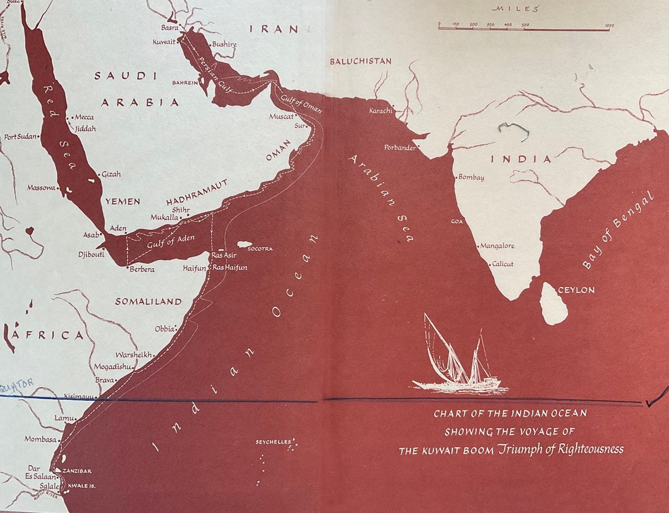
It is important to keep in mind that the oceans shown on this map are bi-sected by the Equator, so the use of the terms Summer and Winter, when referring to the SW and NE monsoon winds, is complicated by the reversal of seasons in the Southern Hemisphere, where Summer, because it is in the Southern Hemisphere, is the AUSTRAL Summer, which corresponds with Winter in the Northern Hemisphere.
Please Note, on Map #1, that the Equator crosses the coast of East Africa at Kismayu, with a “check” symbol placed on the right hand edge of the map page.
Villiers says that the NE Monsoon is really a continuation of the NE trade winds of the Pacific, which blows on the Indian Ocean “when the Sun is in the South.” This refers to the tilting of the Earth on its axis which creates a “reversal” of the seasons between the N and S hemispheres.
(In the southern Summer/Northern winter, the North East Monsoon blows across the (Indian) Ocean.” (Climate Policy Watcher. Last updated on Sat. 01 July, 2023. Ocean Air Circulation.)
TRADE ROUTES
The total area of the Indian Ocean is 27 million square miles, compared to the Atlantic Ocean—both North and South—at 31 million square miles.
The Red Sea is 1200 miles long.
The Bay of Bengal has an area equal to half of Europe.
The distance from the Horn of Africa (Somaliland) to Calicut (Calcutta, India) is almost 1600 miles.
MAP #1 includes the Persian Gulf and the Red Sea. The dotted lines show the route of the Kuwait dhow that Villiers also traveled on as it made many stops along the coast of East Africa.
In thinking about trade routes in the parallel universe of Indian Ocean sail cargo it is important to understand that in spite of the desert, the heat, humidity and the vast areas, there was an active trade of considerable size and variety centuries before the discovery of oil or the building of the Suez Canal.
Calcutta and Goa, both on the West coast of India, have been active centers of trade for centuries. Goa was founded by the Portuguese in 1510 as a trading enclave and held by the Portuguese for 450 years.
The Persian Gulf, with Kuwait and Basra, both large cities, on its North where the Tigris and Euphrates river come together, has extensive wetlands with agriculture, especially dates and rice.
The Red Sea has the Islamic religious center of Mecca on its Eastern coast, attracting tens of thousands of pilgrims each year—all of them needing food, water, lodging, clothing and space in which to pray.
The coast of East Africa has had, for centuries, a number of towns and cities located at points where large rivers run out from the interior to empty onto the coast. These rivers have always been the avenues used to collect and carry valuable trade goods—including slaves, gold, diamonds and ivory—to the coast of East Africa for distribution by Arab and Indian dhows.
All of this trade, in addition to cargoes coming West from India and Ceylon (Myanmar) was carried by dhows powered by the North East monsoon winds as they traveled from India to Arabia, Madagascar and East Africa.
Remember that this kind of sailing, even though it used fore and aft sails, was not like going around the windward mark in a race, or short tacking up a channel.
Villiers makes it clear that the dhows of the Indian Ocean, when they were sailing West to East were, at most, close reaching, mostly on the port tack. If they turned to Port after passing Ceylon and sailed up the East coast of India, they would be doing so on the Starboard tack. They were heavy, deep-hulled boats with large sails and they had been doing this work, in these places and conditions, for centuries.
From Villiers voyage from Kuwait to East Africa, 1938-39, via Bahrain and Oman
THE THINGS THEY CARRIED
As you read about the cargoes listed below I suggest a simple organizing principle based on bulk/volume and value. There are probably more types of cargo than I have listed and you may discover a better organizing principle.
Frankincense and Myrrh. Both of these are still used by several religions for religious services and funerals. They are both thought to also have medicinal uses. Remember that the Three Wise Men of the Christian Nativity story brought frankincense and myrrh, probably carried in the saddle bags of their camels. Both of these substances come from the sap of certain trees found along the coast of East Africa.
Ivory (in the form of elephant tusks), comes from the interior of Africa. When you see old, elaborate Chinese ivory carvings, ask yourself where the ivory came from, and how did it get to China?
Gold and Diamonds also coming from the interior of Africa.
Ghee, clarified butter, meaning that the milk-based solids are removed by carefully heating and straining. Ghee comes from India and because it is a liquid would probably be carried in hard containers made of ceramic or metal. Ghee was and still is used as cooking oil.
Carpets, probably from India and the Persian Gulf.
Cotton textiles and clothing came from India.
Spices and Aromatics, from India, Ceylon, Malasia and Indonesia—the Spice Islands of the Age of Discovery.
Teak wood, from the Malabar Coast of SW India.
Dates grown around Basra at the N end of the Persian Gulf.
Rice, also from the Basra region; the wetlands of the Tigris/Euphrates delta, North Persian Gulf.
Metals, both precious (gold and silver) and useful (copper, iron, tin, steel, bronze) coming mostly from India
Salt, from several location. “Made” using salt pan evaporation basins, not mined.
Flax and Cotton, from India.
Coconuts, Coir and Copra, Coir is a rough fiber coming from the inside of coconut husks, used for making rope. Copra is the white “meat” of coconuts, from inside the hard shell. To make copra the nut is split open, the meat dug out in chunks and dried in the sun. The dried meat is then bagged and shipped, to be used as animal fodder or pressed to make coconut oil. This is still being done in Polynesia, in the Republic of the Marshall Islands. See my blog, S.V.KWAI.
Mangrove Poles, still being harvested as a commercial resource along the coast of East Africa in places like LAMU and the RUFIJI river delta (See Map). The poles are stacked on the deck of the dhows and carried to small towns and cities to be used in building, as scaffolding and roof rafters. Given the abundance of mangroves the poles are a sustainable resource of considerable value in an arid environment lacking straight, strong trees.

Sailors working on a deck covered in mangrove poles from Alan Villiers' photographs of his voyages aboard Arabian dhows (1938-39)
The Indian Ocean and the Arabian Sea have seen a lot of changes with the advent of reliable and affordable marine engines, as well as the economic and political consolidation and growth of former tribal areas and colonies. But a considerable amount of trade has continued while the production and transport of petroleum has grown exponentially.
Wealthy Arab princes and businessmen now own sleek, luxurious dhows that are raced by professional crewmen. So, to some degree, the beauty and power of the lateen rigged dhows is still on display.

SIC TRANSIT GLORIA MUNDI.
EPILOG.
The most recent issue of Woodenboat magazine, Sept/Oct 2023, Number 294, has an article on a modern lateen sloop, the GOZZO 650 (21 feet long). Designed in Milan, Italy, the Gozzo is a “pocket cruiser” with bilge keels and a traditional lateen sail.
The article states that the design “is based on a small, double-ended fishing boat native to the Tyrrhenian and Ligurian Seas off western Italy.”
The final sentence of the design reviewer, Tad Roberts, a boat designer in British Columbia, reads, “I admire this hull for its strong character and superior seagoing ability. The versatile rig adds interest and a wonderful connection to the Ligurian fishermen of the 1700s.”
I could not have said it better myself.
PAU
As always, all ideas and opinions above are mine alone.
Duncan Blair
References:
Frontis piece map. The Sons Of Sinbad, A. Villiers, 1969
The Monsoon Seas, A. Villiers,1952
Sons of Sinbad, A.Villiers, 1969
Duncan Blair’s Traditional Sail Website can be found HERE